
Walk a Richmond Street
A street search works best as a chain, not a single query. First confirm that the address is recognized. Then move from the mapped site to its parcel number and legal description. The Wayne County Assessor, Beacon, county GIS, Richmond BS&A, and the Recorder each hold a different part of that chain. Keep the date of each result because ownership, assessments, permits, and map layers change.
The strongest join key is the parcel or PIN plus the situs address, legal description, and date. A situs address means the physical location assigned to the parcel. It is not necessarily the address where the assessed owner receives mail. That distinction prevents a common street directory error.
- Normalize the street number, direction, suffix, unit, city, and ZIP through USPS or the Wayne address-point layer.
- Open Beacon or the parcel GIS and save the PIN, owner field, situs, tax-mailing address, and legal description.
- Check neighboring parcels by map browse, but record each parcel separately rather than merging a whole block into one household.
- Use the legal description or party name in the Recorder index, then follow older books or microfilm when online coverage ends.
- For a dated household, consult Richmond directory street sections and translate historic names before comparing years.
This order separates address validation, assessed ownership, recorded title events, and historical occupancy. None of those fields alone establishes every person at the address.
Richmond Street GIS Fields
The public Wayne address-point layer is the most precise first check for a typed street. It exposes the assigned address, road name, house number, city, ZIP, unit, PIN, aliases, site type, and match or problem flags. It contains no resident-name field. The separate parcel-owner layer connects mapped polygons to assessed ownership, legal and tax fields.
| Street search field | Record type | Use in Richmond |
|---|---|---|
| ADDRESS, RDNAME, HSNUM | Address point | Confirm number and street spelling |
| NEWZIP, CITY, UNIT | Address point | Test postal area and unit detail |
| PIN, PARCELID, TAX_ID | Parcel | Carry one property across systems |
| HOUSENBR, STREET, ZIP | Parcel | Read the physical or situs location |
| OWNERNAME, BILLADDL1, BILLZIP | Parcel | Separate assessed owner from tax mail |
| LEGALDESCR, DEEDNBR | Parcel | Move to deeds and plats |
The REST service supports filters, geometry, distance queries, statistics, and several export formats. Save the filter and capture date when browsing a whole Richmond street. The service caps a response at 2,000 records, so a narrow street query is more reliable than a countywide download.
See the source screen for the Wayne address-point service before using its fields.
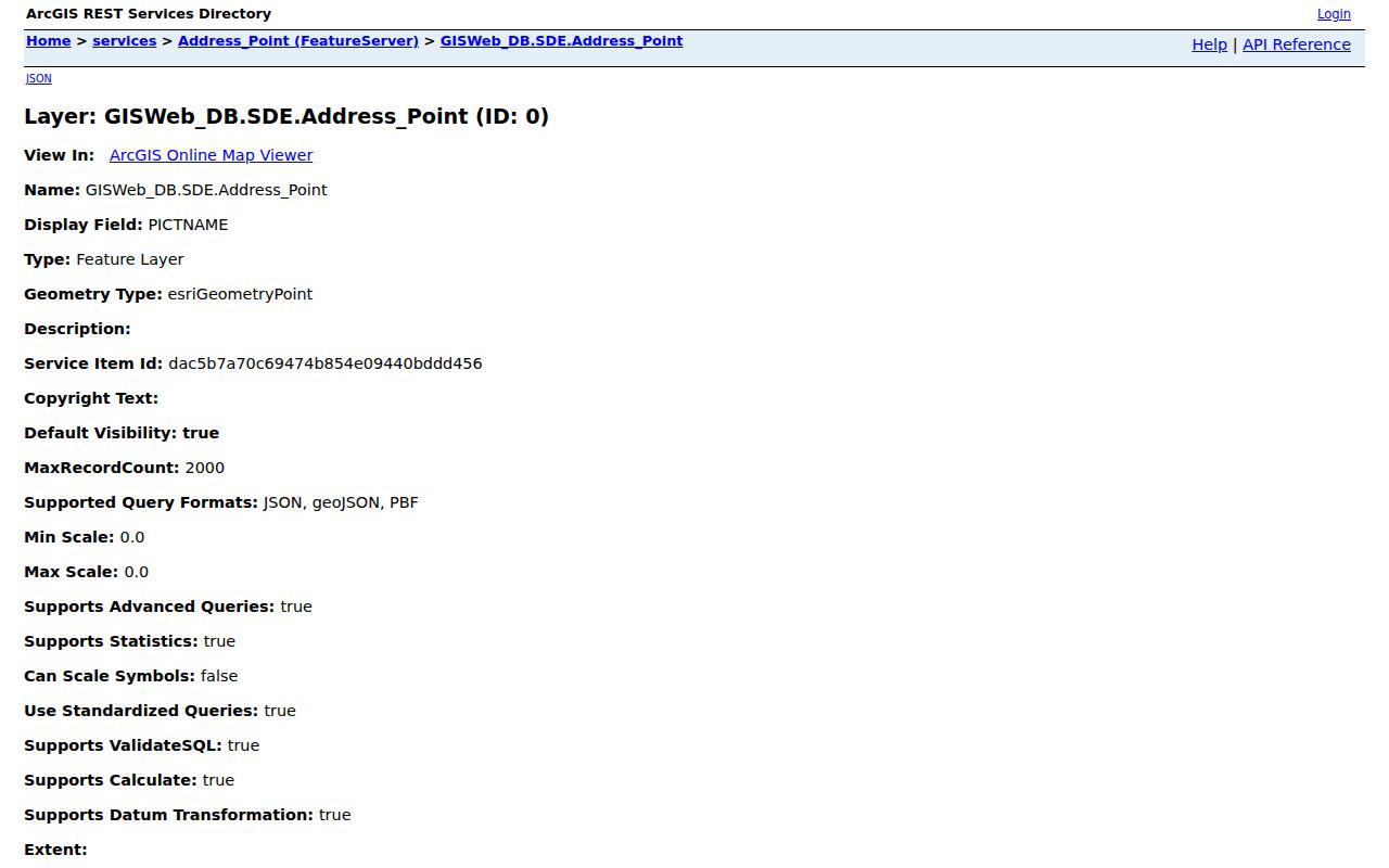
The layer view documents the address schema that supports consistent by-address searches.
Richmond Records By Address
The Richmond street directory draws on several address-keyed sets. Each has its own keeper, time span, and limit. The table keeps those roles separate so an assessed owner is not mislabeled as an occupant and a permit party is not mistaken for a deed holder.
| Address record | Keeper | What the entry adds | Access boundary |
|---|---|---|---|
| Parcel card | Wayne Assessor and Beacon | Owner, PIN, situs, mail address, value, land and building facts | Public web route; current assessment context |
| Parcel and address GIS | Wayne County GIS | Geometry, address points, aliases, legal description, deed number, ZIP | Public viewer and REST layers |
| Recorded instrument | Wayne County Recorder and Doxpop | Parties, type, date, legal description, book or public ID | Office records to 1811; index 1994+, images April 2000+ |
| Permit and inspection | Richmond BS&A | Property, applicant, contractor, work, inspection, attachments | Public property search in city and two-mile fringe |
| Planning case | Richmond Planning | Address, owner name, case type, board action, date | Dashboard includes BZA history to the 1960s |
| Historic directory or map | MRL, State Library, Library of Congress | Dated occupant, business, street sequence, or building footprint | Scan, reading room, microfilm, or archive request |
When a portal fails, use the office route. The Wayne County Recorder maintains older instruments and can direct researchers to books, scans, microfilm, and copies. The Assessor and county GIS offices share the Annex at 401 E Main Street. Richmond municipal files can be requested through the city Law Department under Indiana APRA when a public record exists and is described with enough detail.
Note: APRA supports requests for existing records, but an office need not create a new list of everyone living on a street.
Who Owns Richmond Parcels
Beacon offers a human-facing search by name, address, or parcel ID. Its Richmond resource page also identifies sale, subdivision, section, and map routes. The GIS parcel layer gives a field-level check when the live Beacon controls are hard to reproduce. Owner, situs, billing, legal description, deed number, year built, acreage, area, and taxable fields can all appear, but they serve assessment rather than household registration.
A vacant lot, business parcel, church, condominium, or remote owner can sit beside a home. Review the active and improved flags, parcel shape, and site type before drawing a conclusion. Multiple address points may share one parcel, and one address can contain units that the parcel roll does not list separately.
The official Wayne County Assessor page links the public property tools and explains the assessment role. It is a better source for current assessed ownership than a copied commercial profile.
The manifest image comes from the Wayne parcel-owner layer.
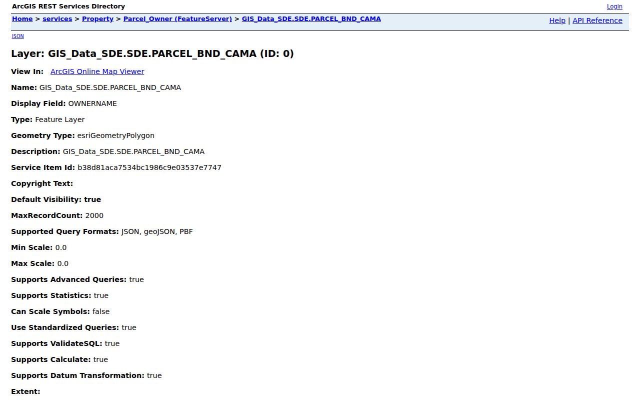
Its separate situs and billing fields show why one address should not be treated as proof of residence.
Richmond Streets Through Deeds
The Recorder holds deeds, mortgages, releases, assignments, plats, surveys, annexations, liens, affidavits, powers of attorney, and other instruments. Doxpop supports party and recorded-date searches plus document, address, legal-description, addition, lot, block, section, township, range, and quarter criteria described in its help. Platted and unplatted search fields are distinct.
Start with the current legal description or deed number from GIS. A legal description identifies land through a lot and subdivision or a survey-based description. Search that description backward, record every party role, and inspect the original image when available. A grantor transfers an interest and a grantee receives one, but a party may also be a lender, trustee, or lien claimant.
- Parcel
- A mapped unit of land with a county identifier; it may contain more than one structure or address.
- Situs address
- The physical location recorded for the parcel, separate from the tax mailing address.
- Plat
- A recorded map dividing land into lots, blocks, streets, or easements.
- Criss-cross directory
- A directory arranged by street and house number rather than only by surname.
Property Watch sends free name-based filing alerts, but the Recorder warns that documents may omit street addresses or parcel numbers. Treat an alert as a prompt to inspect an instrument, not as a title opinion.
Richmond Street Permit Trail
The city’s BS&A portal joins county property context to Richmond permits, inspections, zoning, code, requests, and billing. It searches by address, name, or parcel number. Detailed files may identify an owner, applicant, or contractor, each of whom has a different relationship to the site.
The Planning and Zoning office handles annexations, subdivisions, rezoning, variances, dedications, and vacations. Its dashboard searches by address, owner name, and case name, with Board of Zoning Appeals history back to the 1960s. Preserve the case date and action. A decades-old variance is property history, not current occupant evidence.
The permit page says small projects may take about five business days and larger work up to 15. New construction and zoning work requires a pre-planning meeting. Those time frames describe review, not the age of every online record.
The permit source is shown in this Richmond permits capture.

It points a street search toward project files tied to the property rather than a broad name list.
Richmond Streets Changed Names
Historical address work in Richmond requires a name crosswalk. Morrisson-Reeves Library’s 1881 street-name sheet uses Main as the east-west base and Whitewater as the north-south base. Jackson became 1st, Green became 2nd, Washington became 3rd, and several older names could map to the same numbered street. Front, Madison, and Bridge map to 4th; Marion, High, and Gaar map to 6th.
The lettered streets also absorbed several names. Broad and Spring became North A; Sassafras, Short, and Grant became North C; Noble and Division became North E. Walnut became South A, Market became South B, and Sycamore or South Park became South C. Williamsburg Avenue changed to Bridge Avenue in 1894, while a separate 1929 sheet documents west-side changes.
Search the original form and the modern form. Add the direction and directory year. Keep the old spelling in notes, followed by the modern equivalent and the ordinance year. That makes a Richmond street directory result reproducible and guards against assigning an old entry to the wrong modern block.
Note: A missed old-name conversion can look like a vanished home even when the same building appears under a later street label.
Richmond Address and ZIP Checks
USPS formatting and Wayne GIS solve different problems. The USPS ZIP Lookup standardizes a mailing address. The address-point layer tests whether the county represents its number, unit, alias, PIN, and ZIP. A ZIP is a delivery area, not a city boundary, and an address outside Richmond can still use a Richmond mailing name.
Retain the exact result, including direction and unit. Then compare it with the parcel situs. If they differ, confirm whether the input is an alias, a multi-unit site, or a mailing form. Do not force a match. For a street-wide query, limit results by the road-name field and verify house numbers one by one.
Richmond Blocks in Context
The May 1891 Richmond Sanborn set contains 29 sheets. It shows block form, structures, uses, and then-current street labels, but no current ownership. Pair a sheet with a dated city directory, the MRL street crosswalk, and a Recorder legal description. That stack is especially useful in Old Richmond, Starr, Downtown, Reeveston, and the Pennsylvania Depot area.
Richmond’s park history supplies other old place terms. Camp Wayne, Glen Miller Park, Starr Park, Mary Scott Park, Middlefork Reservoir, Springwood, and the former Northwest 7th Street Park can appear in local sources when a modern address is absent. Search the place name with a nearby street and year.
For the historical directory shelf itself, use the Richmond city directory collection. The street page stays focused on converting one block or address rather than describing every volume.
Richmond Street Directory Limits
Public property data can show an assessed owner, parcel, tax address, deed party, or project party. It does not list all household members, visitors, utility customers, or people using a protected address. The Indiana voter portal checks one person’s registration and polling details; it is not an open street roster. Broader voter-file access uses the Wayne County office and the VRG-24 statutory process, with requester, use, fee, and disclosure controls.
Commercial neighbor tools combine public and private data with uneven dates and accuracy. Official records are narrower but clearer about what a field means. Confirm a name in its original record and preserve the record date. Stop when a protected or private source would be needed.
Lawful use. Use Richmond address records only for legitimate personal, family, property, or civic research. Never use them to stalk, harass, intimidate, or harm anyone.
A street directory cannot prove who sleeps at an address today. It can build a dated, sourced account of parcels, ownership events, land-use cases, and historical household entries. That is the sound limit of the record.